Blog
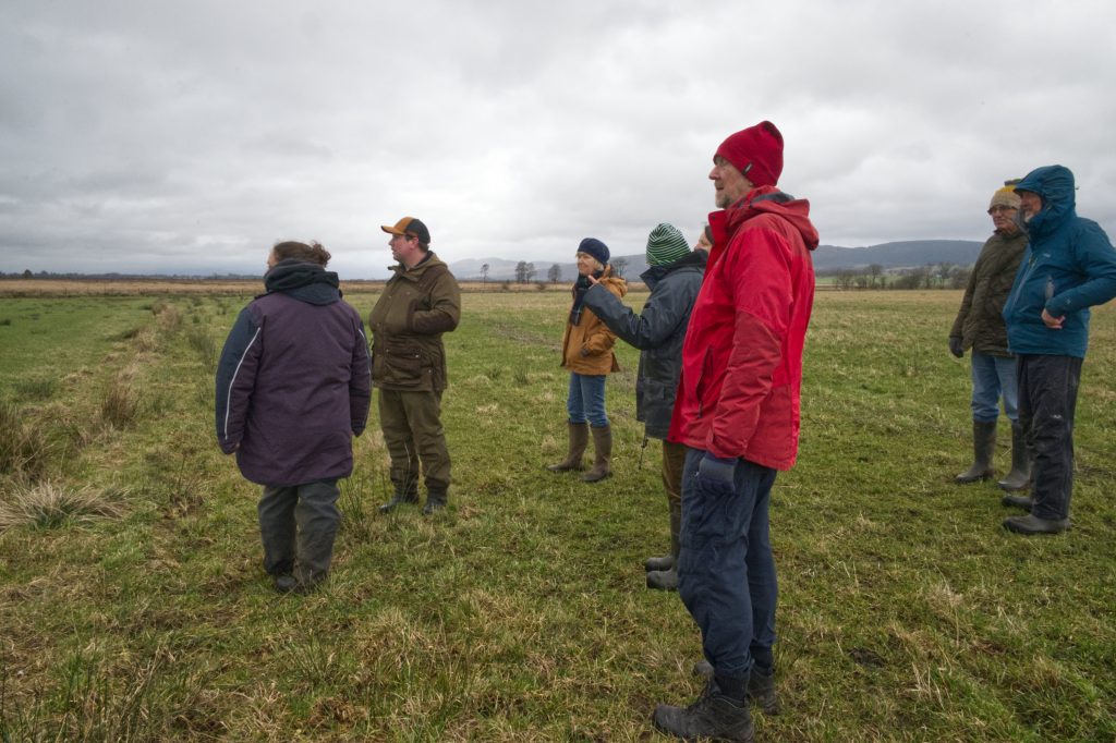
West Moss-side Organic Farm Walk

6 February 2026 – Led by Kate Sankey
Background
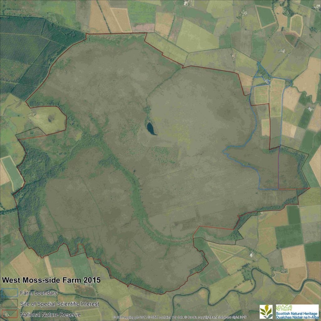
West Moss-side Organic Farm is a typical Carse farm of approx. 60 hectares. It lies on the south bank of the Goodie Water 1.5 miles west of Thornhill on the Carse of Stirling. It includes 20 ha of Flanders Moss NNR. The farmland was created in the late 18th century through the removal of up to 5 metres of peat to expose the underlying mineral rich marine clays. It is hard to imagine the task. Although subject to water logging and flooding the resulting ground grows exceptional grass. The traditional Timothy grass is still grown for the hay market, mainly in small bales for horses, because the grass is extremely stalky with little dust. Much of the Carse ground is now producing silage (large baled, wrapped and preserved grass) with up to 4 cuts per year. This is for on-farm use and there are several large dairies, as well as some beef suckler herds. West Moss-side continues to make hay and haylage (large baled, wrapped) from species-rich grasslands and herbal leys. The haylage is for winter feed for the rare breed pure Shetland beef-suckler herd. The hay is sold to organic farms (mainly beef) to the north and west. Kate has been at West Moss-side since 1991 and in sole ownership since 2003, though the farmland was acquired in 1999 following a campaign to stop a peat company extracting peat. But that is another story.
The Walk
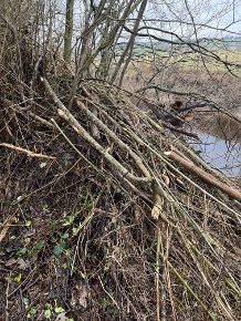
Stop One: the farm bridge. This stone bridge is the only access to the farm (and the neighbouring property). The level of the river fluctuates dramatically and occasionally in the winter it bursts its banks and spills onto the fields. The river was canalised mid 18th century and dredged/reprofiled regularly up until 1992 by the Forth River Purification Board (now SEPA) under a Drainage Act which was repealed. Since then the West Moss-side side of the river has been revegetated (rewilded) with willows and alder since 1999. The river is beginning to re-meander naturally and debris collects to form incipient ‘leaky dams’. Since 2023 the arrival of beavers are adding to the dynamic forces at work! The river was thought not to be suitable for beavers to construct a lodge as the levels fluctuate too much. In a down pour the river can rise by 800-1000mm in 24 hours and then fall just as quickly. It is subject to tidal effects – as the R.Forth can form a barrier at high tide, at the confluence of the Goodie Water and the Forth (at the Doune sawmill).
There has been one major flood in December 2006 where many houses on the Carse were threatened. Flooded fields are commonplace and farming just has to adapt.
Despite this characteristic, a Lodge can be seen upstream of the bridge. A chaotic pile of substantial branches has been piled up on the bank, when it was constructed (November 2025) the entrance would have been underwater. However, since then the river has been much lower and the lodge is left ‘hanging’. Whether it is still in use is questionable.
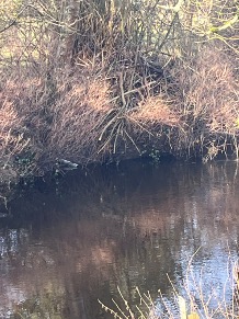
Over the years wildlife has returned. Otters are regularly seen with evidence along the banks especially at the eastern part of the Goodie Water stretch. Kingfishers are occasionally seen as are Daubenton’s bats.
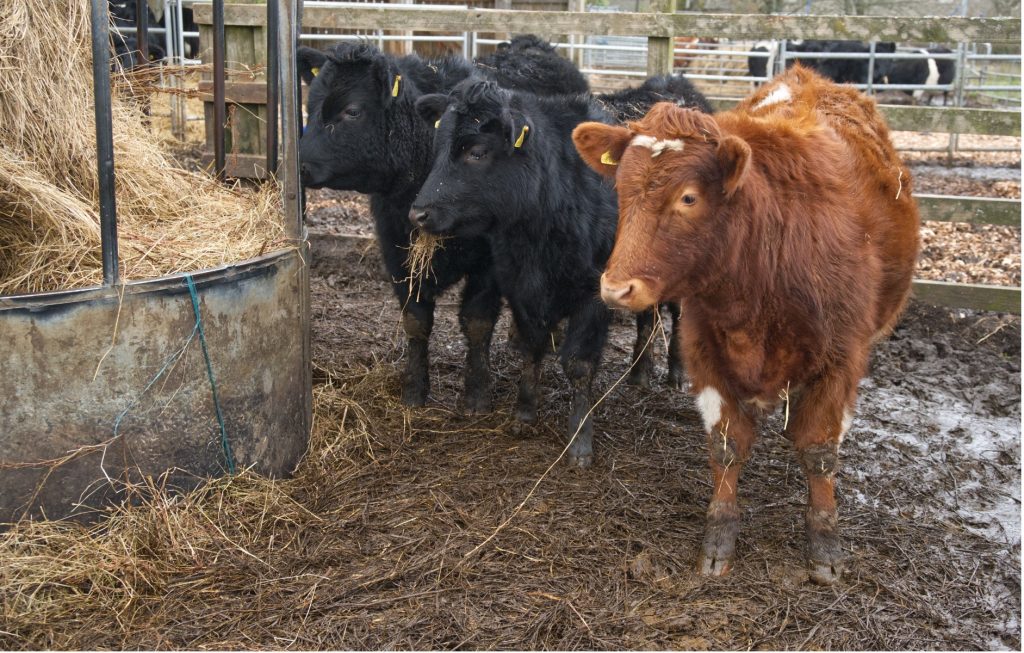
Stop Two: Cattle shed and hay fields. The open Yorkshire-boarded cattle shed was built in 2017. The back of the shed faces west giving shelter against the prevailing winds. It is built of timber from the local sawmill. This had to be built as the winters had become wetter meaning that the ground would not support the cattle (even though they are small and light weight) without considerable damage to the soil. Kate also stopped growing barley for the same reason in 2004. Though other reasons included – combine harvesters won’t fit over the bridge and growing such a small amount meant that the grain merchant were not really interested, and again the grain lorries are articulated lorries, and they can’t get down the lane. All factors mitigating against small scale production.
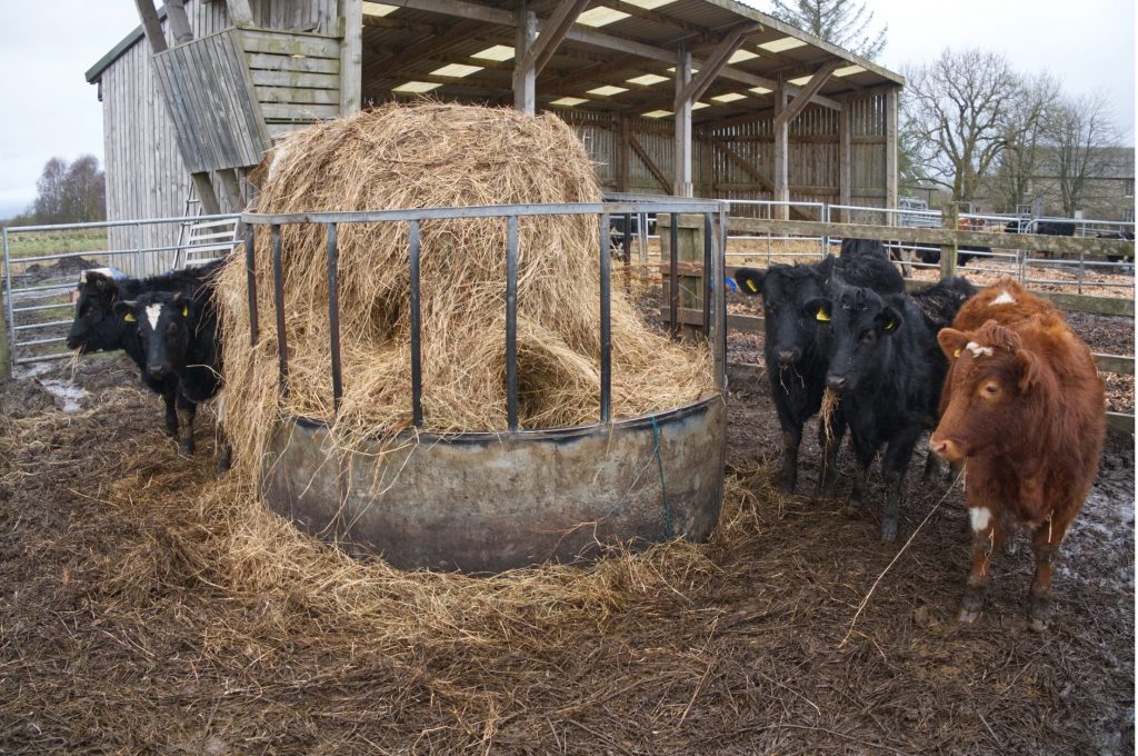
9 month old calves: heifers on the left, male calves on right. Haylage in the ring
The fields are reseeded when the soil conditions are right. Slot seeded would obviously be the preferred way – to preserve soil structure. However, under an organic system on this wet land, rushes are a problem. Although the rushes are tolerated, they are cut to weaken them and a reseed requires ploughing to eliminate the tussocks. There is an aesthetic problem too. A rush filled field means in many farmers’ eyes an unkept pasture and poor farm management.
The reseeding is with a herbal ley. – a mixture of grasses not dominated by ryegrass and Timothy together and with a variety of herbs:
6.00% C1,ORGANIC DICEROS Cocksfoot 14.00% C1,ORGANIC ASTONCRUSADER Hybrid 15.00% C1,ORGANIC GUSTO Ryegrass (int dip) 7.00% C1,ORGANIC REVANSCH Meadow Fescue 6.00% C1,ORGANIC TOWER Tall Fescue 12.00% C1,ORGANIC HEBE white clover 1.00% C1,WHITE CLOVER BLENDX 12.00% C1,LOFA Hybrid / Fescue 3.70% C1,PUNA Chicory 1.50% C1,SALAD BURNET 1.50% C1,TONIC Plantain 0.60% C1,SHEEPS PARSLEY 2.00% C1,CRIMSON CLOVER 0.50% C1,BIRDSFOOT TREFOIL 0.20% C1,YARROW 7.00% C1,SCOTS Timothy
This mixture has been recommended for West Moss-side by the agronomist at Dodd’s Seeds. The theory behind a herbal ley is that the roots are of varying depths and that grasses other than ryegrass have an associated rich mycorrhiza, thus releasing nutrients from the soil that otherwise would not be available. Ryegrass in contrast (although the universal grass species) have very little associated mycorrhiza and so rely on artificial fertiliser. The fields pH is around 6.00 and seaweed fertiliser is applied in the spring together with a bio boost (more mycorrhiza!). The soil has comprehensive soil analyses every other year using the Albrecht system. This identifies in detail all the elements which are deficient. Thus, informed decisions can be made for any additional inputs although the cost of some applications can be unsustainable.
The fields are cut for hay in early July or thereafter depending on the weather. Hay is made not silage so that any ground nesting birds are well fledged and away before the cutters go on the field. Early cutting for silage (early May) is one of the reasons why we have lost the iconic birds of lowland grasslands – curlew, peewit, oyster catcher and snipe. West Moss-side has been activity managing the grassland and the surrounding wet fen for these birds. Each year we have managed to get 2 or 3 pairs of curlews away. Other wildlife of the hayfields – the bird list is over 100 and fields are full of insects, honeybees, butterflies and dragonflies. Hares are prolific and roe and red deer night visitors!
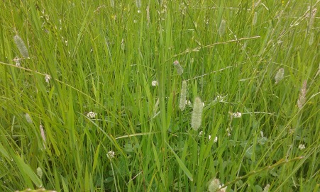
Organic grass mix note the clover and mixed grass species (June)
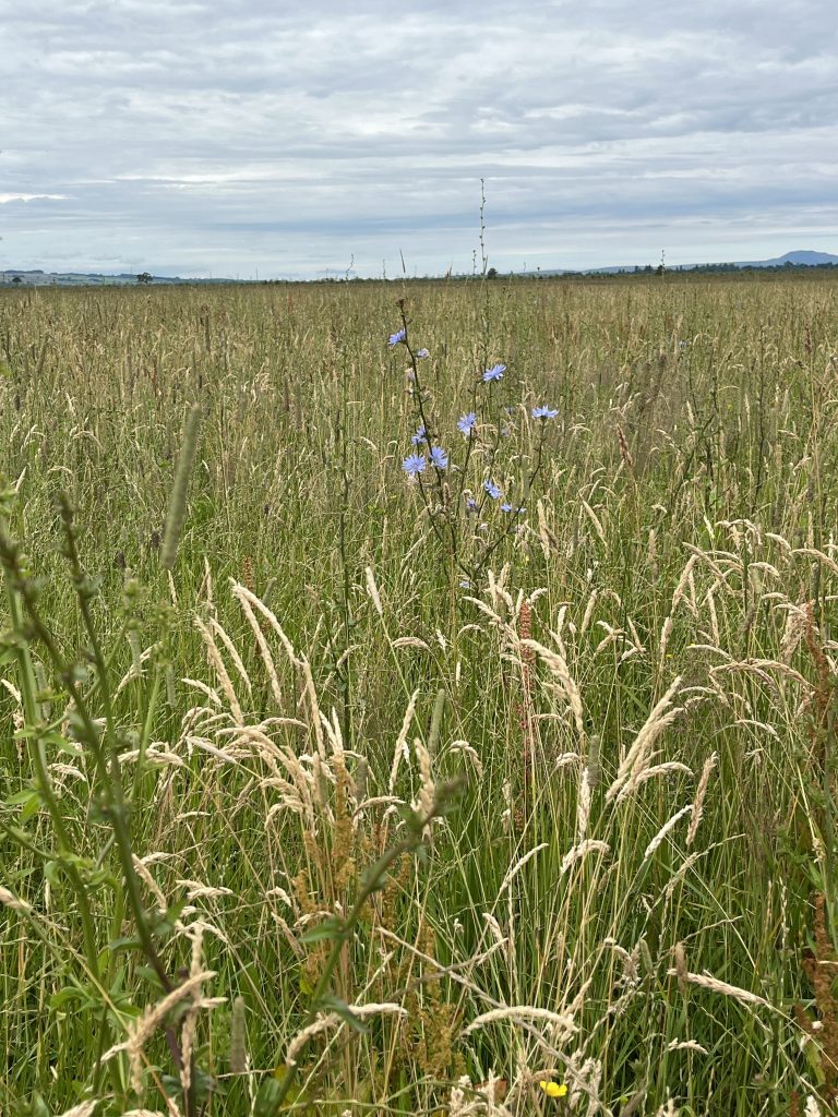
Organic Herbal ley note the grass mix and herbs including chicory (July)
Stop 3: view of lag fen, the rough and high moss. From halfway up the hay fields there is a good view of the edge of the bog to the west where a lag-fen creation scheme was carried out in 2013. This was an SNH demonstration project to build a series of dams, sluices, ditches and bunds to spill water from the Pow (water course to the west) onto the edge and so wet up the bog edge whist stopping water escaping onto ‘productive’ hay fields. The edge of the bog can be seen to the south as a step up (approx. 2metres) from the hay fields. This represents the ground where only a few metres of peat was taken off before abandonment in the early 19th century. This is called ‘the rough’. The Shetland cattle graze this area, and the rushes are cut once a year when soil conditions allow. From this point the next step up onto the High moss can also be seen – this is where no peat has been taken off and is Flanders Moss at its most pristine. The main conservation management challenge is to keep the birch scrub at bay. The edge birch woodland was cut down annually 1999-2003 and subsequently kept under control by putting young stock on the high moss in May – August and also by brush cutting in February before the nesting season. Over the years SNH/Nature Scot have done a considerable amount of peat restoration – damming ditches, creating dams and bunds. It has been a demonstration site for training and data has been collected on the impact. It certainly feels like the bog has got wetter and sphagnum moss is increasing.
Stop 4: Final stop at edge of rough. There is a bund which encloses the most southern part of the hayfields. This area has been relinquished to the bog as it was always extremely wet and remained flooded longest after a wet spell. This is now reverting to bog with sphagnum species colonising. The rough is defined as a ‘grassland on peat’ and there is a flux tower measuring CO2 and methane exchange. The equipment belongs to James Hutton Institute and is generating a massive amount of environmental data. There is a similar tower to the west (Stirling University) which is on the bog itself which will give information about the differences in CO2/methane flux on ‘peat’ to that on ‘grassland on peat’.
The Farm trail also included seeing the Shetland Cattle (males plus Jericho, the bull, in the shed in the yard) and also the in-calf cows and last years’ calves in the field shed. The features of Shetland cattle were discussed including their value as Conservation Grazers. The steers go to the butcher at 29 months and the beef sold from the farm freezer. The problems of small scale and organic beef production were raised.
Nine month old calves
We did not actually set foot on the bog as time and the easterly wind and dampness was against us! We also did not look at the beaver water management – another trail is required.